
Rockhounding Oregon
Oregon is an extraordinary state for rockhounding. It is one of the very best states in America for recreational rockhounders. Oregon has a large amount of public lands and a wealth of fossils, gemstones, rocks, and minerals. There are terrific collecting opportunities, in a wide variety of landscapes, for thundereggs, obsidian, petrified wood, sunstones, agates, fossils, etc. In addition, Oregon also is home to some outstanding geologic formations – some of which are within National Parks or National Monuments.
State Rocks, Gemstones, Minerals, Fossils, & Dinosaurs
Rockhounding Tip: Knowing state rocks, gemstones, minerals, fossils, and dinosaurs often can be very useful information for rockhounders. Ordinarily, states with significant mineral deposits, valuable gemstones, fossils, or unusual or significant rock occurrences will designate an official state mineral, rock/stone, gemstone, fossil, or dinosaur to promote interest in the state’s natural resources, history, tourism, etc. Accordingly, such state symbols often are a valuable clue as to potential worthwhile rockhounding opportunities.

Thunderegg (cut and polished)
State Rock:
Thunderegg (1965)
Oregon designated the ‘thunderegg’ as its official
state rock in 1965. Thundereggs (also
thunder eggs) are a specific type of geologic structure that form in
silica-rich rhyolitic lava flows.
Thundereggs are spherical masses of rock that range in size from less
than an inch to over four feet in diameter.
Many are about the size of a tennis ball. They have a knobby rind of drab, siliceous
rock and a cavity (often star-shaped) typically filled with agate, jasper, or
common opal. Accordingly, although nondescript
on the outside, they reveal exquisite designs in a wide range of colors when
cut and polished. The best-known thunderegg
localities in Oregon occur in the John Day Formation of late Oligocene to early
Miocene. Thundereggs are found chiefly
in Malheur, Wasco, Jefferson, Wheeler, and Crook counties on the eastern side
of the state.

I'm digging out a thunderegg in central Oregon in 2008

Sunstones
State Gemstone: Sunstone (1987)
Oregon designated sunstone as its
official state gemstone in 1987.
Sunstone is a variety of a mineral called oligoclase. Uncommon in its composition, clarity, and
colors, it is a large, brightly colored transparent gem in the feldspar family.
Inclusions of hematite and copper give the mineral
a golden shimmer. In Oregon, sunstone occurs
in the south, central portion of the state near the California border.

Metasequoia fossil
State Fossil: Metasequoia (2005)
Oregon designated the fossil leaf Metasequoia is its official state
fossil in 2005. These conifer trees,
relatives of living pines, junipers, and yews, were widespread members of
northern swamp forests during the latter half of the Tertiary Period. Although the Metasequoia fossils found in Oregon date from the Miocene Epoch
(25 - 5 million years ago), the genus itself is not officially extinct (a grove
of living trees was discovered in a remote valley in China in 1941). The tree is known in the horticultural trade
as the "dawn redwood."
Rockhounding Resources
State-specific rockhounding books (including the books listed here as well as other books), regional rockhounding site guides, and other helpful rockhounding resources are identified - by category - in the Books & Gear section of Gator Girl Rocks with a link to the Gator Girl Rocks Amazon Store where you may easily browse selected resources and securely place an order. Your order will benefit Charity Rocks!
Oregon Department of Geology & Mineral Industries
Bureau of Land Management - Oregon
Enormous portions of the State of Oregon are
federal public lands managed by the Bureau of Land Management (about sixteen
million acres – an area bigger than some states). The BLM publishes a very useful rockhounding
map.
Willamette Agate
& Mineral Society
The Willamette Agate & Mineral
Society (not to be confused with the Washington Agate & Mineral Society) is
an active Oregon rock club with useful information.

North America Research Group
Recreational fossil collectors in Oregon &
Washington.
- David D. Alt & Donald W. Hyndman, Roadside Geology of Oregon (1st ed. 1978).
- R. H. Cate, Agates of the Oregon Coast (1977). This book includes good pictures and a general map of where to look along the Oregon coast.
- OMSI Field Guide, Oregon Under Foot - Agate, Jasper, Opal & Related Gems (3d ed., 2002).
- The Rockhound's Map of Oregon (1982).
- H.C. Dake, Northwest Gem Trails (3d ed., 1962 - originally published in 1950).
- Elizabeth L. Orr, Oregon Fossils (2d ed. 2009).
- Ellen Morris Bishop, In Search of Ancient Oregon: A Geological & Natural History (2006).
- David D. Alt & Donald W. Hyndman, Northwest Exposures: A Geologic Study of the Northwest (1995).
- Garrett Romaine, Gem Trails of Oregon (3d. ed., 2009).
- James R. Mitchell, Gem Trails of Oregon (Rev. ed., 1998).
- Allan W. Eckert, Earth Treasures Vol. 3 – Northwestern Quadrant (1986; reprint in 2000).
- James Martin Monaco & Jeannette Hathway Monaco, Fee Mining & Rockhounding Adventures in the West (2d ed. 2007).
- Kathy J. Rygle & Stephen F. Pedersen, Northwest Treasure Hunter's Gem & Mineral Guide (4th ed. 2008).
Five Elements Gem & Mineral Gallery Rock Shop
Eugene, Oregon
A great local rock shop for rocks, minerals,
gems, and fossils. The owner also offers
fee access guided sunstone mining tours.
As you can see from the picture, the Gator Girl has stopped by.
Fossil Cartel
Portland, Oregon
A great local rock shop in downtown Portland. The Gator Girl has visited the Fossil Cartel.
Museums of Interest to Rockhounders
Rice Northwest
Museum of Rocks & Minerals
Hillsboro,
Oregon
The Rice Northwest Museum of Rocks &
Minerals exhibits rocks, minerals, gemstones, crystals, fossils, meteorites,
fluorescents, and its ‘Best of the Northwest’
specimens. The
museum also displays the ‘Alma Queen,’ a rhodochrosite specimen from the famed
Sweet Home Mine (Park County, Colorado) that is considered one of the best
examples of the species in the world. In addition, the museum is home to the largest known opal-filled thunderegg, which weighs approximately 3,500 pounds and was found at Opal Butte in Oregon.

Crater Rock Museum
Central Point, Oregon
The Crater Rock Museum really is an
extraordinary rock, mineral, gemstone, and fossil museum. We visited the museum and were very
pleasantly surprised. The museum’s exhibits include a collection of world-class minerals, as well as a large collection of petrified woods and indigenous
rocks of Oregon, the U.S., and Mexico.

Baker Heritage Museum
Baker City, Oregon
The Baker Heritage Museum in northeastern
Oregon has a fine collection of rocks, minerals, gemstones, and fossils. The Baker area is the site of an historic
gold mining district. The museum
recounts this history. In addition, the museum also houses two extensive rock and mineral
collections - the Cavin-Warfel Collection of rocks, fossils and minerals and
the Wyatt Family Collection of agate and jasper cabochons.

Mineral & Crystal Display Collection
Oregon State University – Corvallis, Oregon
Oregon State University’s Geosciences
Department has a fine display of rocks, minerals, and crystals in Wilkinson
Hall.

Geology Department
University of Oregon – Eugene Oregon
The University of Oregon’s Geology Department
(Cascade Hall) has several exhibits including rock, mineral, fossil, and
meteorite displays.

Oregon State Capitol
Salem, Oregon
The state capitol has an ‘Oregon Rock &
Mineral Exhibit.’ The small exhibit is
located near the Capitol Rotunda. The display is rotated regularly and features
collections from rock and mineral clubs from around Oregon.
Oregon Museum of Science & Industry (OMSI)
Portland, Oregon
OMSI has a small exhibit of rocks, minerals,
and fossils as well as a small paleontology lab.
Places to Visit - Interesting Sites To See

Dad and me at Crater Lake National Park
Crater Lake
National Park
Southern Oregon
Crater Lake National Park encompasses a
volcanic caldera that is the remnant of the Mount Mazama volcano that erupted
around 5700 BC. The caldera has filled
with water and formed Crater Lake, which is approximately 1,950 feet deep and
is the deepest lake in the United States.
There is a cinder cone within the caldera that appears as an island
(Wizard Island). The caldera rim ranges
in elevation from 7,000 – 8,000 feet above sea level.

Mom and me at Crake Lake. Wizard Island is in the background.

That's me in 2008

Mom and me at the enormous obsidian flow
Newberry National
Volcanic Monument
Central Oregon - about 10
miles south of Bend, Oregon
The Newberry
National Volcanic Monument, which is managed by the U.S. Forest Service,
provides a unique opportunity to view the lava lands of central Oregon. The Monument includes over 50,000 acres of
lakes, lava flows, and spectacular geologic features. The monument includes the Lava Lands Visitors
Center, located near Lava Butte, a 500-foot high cinder cone. The highest point within the Monument is the
summit Paulina Peak (7,985 ft.), showcasing views of the Oregon Cascades and
across the High Desert. The summit area
of Newberry Volcano holds two sparkling alpine lakes full of trout and salmon. It is hard to fathom as you drive through the
summit area that you are within a 17 square mile caldera at the summit of a 500
square mile volcano, a volcano that remains very active to this day. Newberry is both seismically and geothermally
active. Geologists believe the caldera
sits over a shallow magma body only 2 to 5 kilometers deep. Visitors see
numerous cinder cones (over 400 throughout the area), miles of basalt flows, as
well as rhyolite flows of with a large obsidian flow created about 1,300 years
ago that covers 700 acres.

Me at the top of Lava Butte


Inside the Lava River Cave in 2008
Lava River Cave
Newberry National Volcanic Monument
Lava River Cave, which is located within the
Monument, is a lava tube that is approximately one mile long.

This is one of the casts
Lava Cast Forest
Newberry National Volcanic Monument
At the Lave Cast Forest, visitors may hike
through a 6,000 year old lava flow that includes the casts of ancient
trees. The Newberry Volcano to the south
spewed hot pahoehoe lava to the Earth's surface, spilling through standing forests. The trees became encased in stone when the
lava cooled. What remained were "casts" of the trees, many of which
go down several feet below surface level.

John Day Fossil
Beds National Monument
Wheeler &
Grant Counties, Oregon
John Day Fossil
Beds National Monument protects one of the longest and most continuous records
of evolutionary change and biotic relationships in North America. The National Monument is known for its well-preserved layers of fossil plants
and mammals that lived in the region between the late Eocene (about
44 million years ago) and the late Miocene (about 7 million years
ago). The monument consists of three
geographically separate units covering approximately 14,000 acres: Sheep Rock, Painted Hills, & Clarno. All three
units are in the John Day River Basin. There are more than 750 fossil sites within the John Day Basin. Within these sites scientists have found more
than 2,200 species of plants and animals.
There are no dinosaurs. At the
time of dinosaurs, this present-day desert area was beneath the Pacific Ocean. The Cant Ranch Visitor Center and the Thomas Condon Paleontology Center within the National
Monument include museums that exhibit
fossils.

Mom & me at Oregon Caves National Monument
Oregon Caves National Monument
East of Cave Junction, Oregon
Oregon Caves National Monument features a dissolution cave, with passages totaling about 15,000
feet that formed in marble. The parent
rock originally was limestone that metamorphosed to marble during the geologic
processes that created the Klamath & Siskiyou Mountains. The limestone formed about 190 million
years ago, but the cave itself is no older than a few million years.

Me inside Oregon Caves
Oregon Dunes National Recreation Area
Oregon Coast between North Bend and Florence, Oregon
The Oregon Dunes are a unique area of
windswept sand that is the result of millions of years of wind, sun, and rain
erosion on the Oregon Coast. The Oregon
Dunes are the largest expanse of coastal sand dunes in North America. Some of the dunes tower up to approximately
500 feet above sea level.
Shore Acres State Park
South of Coos Bay, Oregon
Shore Acres State Park includes interesting
concretions weathering out of the Cliffside.
Devil's Punch Bowl
State Natural Area
Oregon Coast
Located at Otter Rock, between Newport
and Depoe Bay on the Central Oregon Coast.
During winter storms, ocean waves slam with a thundering roar into a
hollow rock formation shaped like a huge punch bowl. The surf churns, foams, and swirls as it mixes
a violent brew. The punch bowl was
probably created by the collapse of the roof over two sea caves, and then
shaped by wave action.
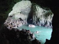
Sea Lion Caves
Oregon Coast – North of Florence, Oregon
Sea Lion Caves is a large cave system at sea
level. The large cave is approximately
twelve stories high. Both Stellar &
California Sea Lions frequent the area.

Willamette
Meteorite
Site
West Linn, Oregon – Corner of 14th Street
& Willamette Falls Drive
The Willamette Meteorite, the largest
meteorite found in the United States – after being stolen, litigated, and
purchased – is sitting in the American Museum of Natural History in New York
City. Originally, however, it was found
in an Oregon forest. Today, in West
Linn, Oregon there is a replica (which does not look like the meteorite)
located about two miles from where the real meteorite was discovered in 1902.

Me and the Willamette Meteorite - at the American Museum of Natural History in New York City

Multnomah Falls
Near the Columbia River, East of Portland, Oregon
Multnomah Falls, in the Columbia River Gorge,
is the highest waterfall in the State of Oregon. The falls drops in two major steps, split
into an upper falls of about 542 feet and a lower falls of about 69 feet.

Hells Canyon National
Recreation Area
Northeastern Oregon
The Hells Canyon
National Recreation Area is home to the deepest river gorge in North America. The ten mile wide canyon is located on the
border between Idaho and Oregon
Rockhounding Sites for Children & Families

Fossils - Oligocene [including Metasequoia (Oregon's State Fossil)]
Fossil, Oregon
The OPLI-managed dig site is located behind Wheeler High School in Fossil, Oregon
located in Wheeler County in north central Oregon. There is a small access fee. The thinly-bedded rocks behind Wheeler High School represent
the bed of a shallow lake that existed here about 33 million years ago, during
a time period known as the Oligocene. The
climate then was temperate, but somewhat milder and wetter than today. Fossils that you’ll find here are mostly
leaves and branches of the deciduous trees that grew along adjacent stream
banks and in nearby wetlands. The plant fossils found
here include the ancestors of modern sycamore, maples, oaks, rose, and alder. A conifer, known as metasequoia, dropped its
needles into the lake every fall and is among the most abundant and best
preserved fossils here.

Sunstones
BLM – Lakeview District – Sunstone
Collecting Area
The Oregon Sunstone Public Collection Area
allows visitors to enjoy collecting sunstones in their natural setting. Orange plastic posts mark the boundaries of
the collection area and corners are marked with large BLM triangles on wooden
posts. Sunstone is located in the remote
Rabbit Basin and due to its isolated location rockhounds visiting the area
should be very well prepared. The only
facilities available at the site are a vault toilet, picnic tables, and a shade
structure. There is no fee for
collecting sunstones. Pursuant to
federal law, however, individuals may NOT collect specimens for trade or
commercial purposes.
Thundereggs
Central Oregon
Thundereggs can be collected at many
sites in central and eastern Oregon, including commercial (fee access) sites. Oregon thundereggs have been collected for
generations. Accordingly, the easy
picking days were in the past. Today,
many collectors expect to dig and work for the thundereggs. Proper equipment, including shovel, pick, and
bar, makes the job much easier. The commercial
sites almost always will have some preparatory work (overburden removal) done. Commercial sites include:

Richardson's
Recreational Ranch
Madras, Oregon
Commercial (fee access) business. This site is the legendary Priday Agate
Beds.
Richardson’s is located approximately ten miles north of Madras, Oregon.

These are some of the thundereggs that we dug out (I had dad cut them and I gave most of them to my schoolmates in my after school rock club)
Lucky Strike
Thundereggs
Mitchell, Oregon
Commercial (fee access) business.

It takes some hard work and determination to dig out a thunderegg
Oregon Sunstone
South-Central
Oregon
Oregon
sunstone is found in Harney and Lake Counties, Oregon north of Plush,
Oregon. The area is a harsh, high desert
environment. There are public federal
lands managed by the BLM that recreational rockhounders may access, subject to
federal restrictions, to collect Oregon sunstone. In addition, there are commercial sites including: Dust Devil Mining Company (Plush, Oregon) & Spectrum Sunstones Mines.

Mom and me with obsidian specimens at Glass Buttes
Obsidian
Glass Buttes - Central Oregon
Glass
Buttes is a well-known obsidian collecting area in Central Oregon’s high
desert. The site is a massive deposit of obsidian approximately four million years old. Glass Buttes is on federal public
lands managed by the BLM (Prineville District).
The site is known for a variety of obsidian including black, mahogany, silver
sheen, gold sheen, rainbow, and other varieties. Subject to federal restrictions, recreational
rockhounders may collect specimens.
Agates
Oregon Coast
Oregon’s
coast contains small agates and jasper.
The central coast often is favored over the southern coast. Eagle Rock is noted for fine specimens
Agates
Eagle Rock – Southeast of
Prineville, Oregon
Eagle Rock
is noted for fine specimens of dendrites and agates. The site is off Oregon Highway 380 (Post-Paulina Hwy.) about 15 miles southeast of
Prineville in central Oregon.
Agates
Maury Mountain – Southeast of Prineville,
Oregon
There are four separate
public mining claims in this area, which is known for its yellow, green and
moss agates. The site is off Oregon Highway 380
(Post-Paulina Hwy.) about 40 miles southeast of
Prineville in central Oregon.